Cycling the Kystriksveien (RV17) in Norway
home![]() cycling
cycling![]() Kystriksveien, 2006
Kystriksveien, 2006
Updated 30 March 2008
|
Cycling the Kystriksveien (RV17) in Norwayhome Updated 30 March 2008 |
|
|
The Kystriksveien is a 670 km route along the RV17 coast road from Steinkjer in Trondelag to Bodø in Nordland, Northern Norway. We cycled along 450 km of the juicy bits (using ferries and a couple of buses for the rest) between 29 July and 13 August 2006.

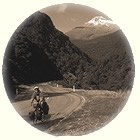
You get the road pretty much to yourself
The Kystriksveien is known to just a few touring cyclists who appreciate how quiet and scenic it can be; it isn't a destination that sees a lot of cyclists, even during the high season between June and the second week of August. We saw about a dozen other cyclists during our two weeks on the tour.
Traffic is generally light, but some sections are busier with cars and motorhomes, especially near the larger towns and at weekends.
The RV17 itself is billed as being one of Norway's greatest scenic drives, but must be a terrible disappointment if you've hired a car or motor home to drive along it because it is narrow, has limited overtaking possibilities, and forces drivers to travel in convoy at 50 mph in groups of three or four vehicles between ferries. They tailgate each other, looking desperately for a place to pull off the road and relieve themselves/enjoy the view. And at night they are all coralled together into a carpark at a motorhome site to sleep bumper to bumper.
So if you want to enjoy the journey, ride a bicycle instead! Then the road will seem really wide and empty, you'll be able to stop whenever you want to gaze at the jaw-dropping scenery, and you'll feel you've deserved your hot shower and evening meal every day.
We would rate it up there with the Banff-Jasper Icefield Parkway in terms of scenery, but this is a more demanding route. Some sections are gentle or flat, but carrying 52 kilos of luggage between us (and towing P. on the trailer bike) we found 55km per day was just about our upper limit - the climbs are long and steep, and they follow one after another on the hilly days until you find yourself taking a long hard look at the heavy tent, the trailerbike, and your son ("pedal now, dammit!").
Fortunately we consistently found excellent cabins to stay in. These were spaced about 40 km apart; the accommodation looked like it was going to be a real headache because so few beds are available, but it turns out that taking a mobile phone and booking one day ahead generally gets you a hut or a room at your first call; if not, there's usually an alternative within 10 km or so.
Press the spacebar in Explorer or Firefox to page down, it's quicker than using the mouse.
|
If you have Google Earth (GE) running, you can click on this icon when you see it in the text below to view the spot we are describing. It's more fun than looking at a map. |
The mountainous nature of the route would frighten most visitors off, so any topological information has been ruthlessly suppressed by the Norwegian tourist board. You won't find a decent topo-map anywhere unless you search very hard before your trip (hint: try here). I believe that the tourism industry has lobbied hard to prevent Google Earth from getting clearer aerial photographs of the Kystriksveien to maintain the illusion that this area is mostly one of panoramic vistas viewed from a gently rolling road that hugs the valley floor. Don't be fooled, pack pitons and an ice axe if you are touring late in the season because you are going to climb, climb, climb.
It's not easy to find English language guides to this part of Norway, which makes visiting it even more attractive.
For English speakers, a discerning and comprehensive set of general notes on cycling in Norway is to be found on Jon's excellent Cycletourer.co.uk site ... if you can read Norwegian you'll also get good tips from the Syklistenes Landsforening. The guestbook at bike-norway.com is a good FAQ for cycling in the country and goes back to the end of 2000, but I can tell that the people writing responses to the questions aren't really listening to the questions any more, which is a shame because this could be a fabulous resource.
You really want to start your planning with your browser open at the comprehensive website dedicated to the road and accomodation along it, along with a copy of the Nordland 1:400,000 roadmap from Statens Kartverk, ISBN 82-7945-031-9, Order Number 2155 (you can buy this from the maps page at www.rv17.no), or Google Maps. Cappelen publish a map which is sometimes available outside Norway in travel bookshops, but this doesn't show places to stay (as the SK map does) and the ferry routes it does show are somewhat conjectural now.
The most useful thing I've found on the RV17 website is the indispensible pocket-sized Krystriksveien guide, which you can get (for free) from the tourist office in Bodø or Steinkjer, or at any ferry terminal in between.

2006 Handbook - essential!
This handy booklet tells you about accommodation along the route, and a bit about ferry timetables and tunnels; for 2006 it is available as an Adobe PDF download from the site, which is very generous. You need this book before you go, to plan sensible days and get a couple of bookings in for the first two nights at least. Incidentally, this year it provides WGS84/UTM32 co-ordinates for each place listed, but each set is "wrong" according to my GPS - about half a kilometre or more out, which suggests that they didn't correct for Easting (update 10/09/06 - Frode at www.rv17.no assures me they have spotted this and the figures will be correct for 2007). Still it is worth taking your GPS, because no other instructions on finding the building are given, unless you want to be talked in on a mobile phone each night when you stay at the more remote ones!
If you do take your GPS, I'd give anything to get a copy of any logging data you may collect - the OpenStreetMap project is mapping parts of Norway, and the topographical information would be very useful for other people (like me) following in your tracks.
The RV17 site also markets a book on the route by Olav Breen which was published by Cappelen in 2004. The book costs about 300 Kr if ordered through the site, and takes about 10 days to arrive. Actually this is of little use if you are cycling, since it has pitifully little information about the contours you will cross. I think it is aimed at the car driver with an unlimited fuel budget. It is also a little confusing to use. But it is the best guide available to the region, and it's clearly a labour of love by its author; he deserves your support if you can afford it.
The Norwegian Highways Agency has a site that described attractions they've put along the road, and what they've done to make your journey more memorable (other than using a grader on the gravel sections). They have created more rest areas and they seem to do a good job at keeping the roads in mint condition where they have tarmac.
There's also a website dedicated to the Helgelands coast with accommodation info and some fine photos.
Reinhard Pantke has been taking better photos than me of the road and the adjacent Lofoten Islands this year - his flickr photos are outstanding! I note he uses slide film and a Nikon CoolScan scanner, which I used last year with better results than this years' Canon EOS 350D.
The Hurtigruten website has timetables for the shorter ferry routes in English (for the first time this year). You need these to avoid riding for hours to a pier with no ferry ...
If you don't like tunnels, you should be aware that there are a couple of long tunnels on the route. One of these burrows under the Svartisen glacier and is closed to cyclists (can be smoke-filled); we took a ferry to avoid this again, but doing this a third time I'd probably use the local bus instead, which takes bicycles for half the adult fare.
Most Norwegians can speak a little English but they really appreciate you trying to talk in their native tongue. Try the Teach Yourself Norwegian course by Margaretha Danbolt Simons from Hodder and Staughton - the best I've come across. You don't need to learn much Norwegian to book a hut.
The map below shows the route in outline (we start at the bottom):
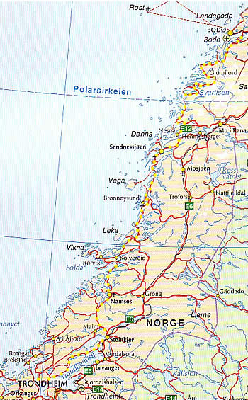
Route Outline (red and yellow dashed road)
Were you planning to fly to Norway with your bike? If not, then here's the travelogue. But if you were, you may want to find out more about this thorny topic by reading our guide to "Flying to Norway With A Bike".
[ Home | Strictly Business | Near Misses | Cycletouring ]